for Tuesday, 18 August 2015 [8:55 PM PhT]

for Tuesday, 18 August 2015 [8:55 PM PhT]![]()


DIRECT CYCLONE HAZARDS AFFECTING LAND
Below are the regions or places in the Philippines that could be directly affected or that are being directly affected by the hazards generated by this current tropical cyclone.
 None for the next 48 hours.
CURRENT CYCLONE INFORMATION
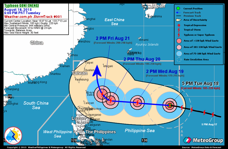
As of 5:00 PM PhT today, August 18...0900 GMT.
Classification/Name: TY GONI (INENG)
Location: Over the southeasternmost part of the North Philippine Sea (near 18.6N 133.7E)
About: 1,255 km east-southeast of Basco, Batanes...or 1,225 km east of Santa Ana, Cagayan
Maximum Sustained Winds (10-min avg): 185 kph near the center...Gustiness: 220 kph
24 hr. Rain Accumulation (near the center and to the north): 100 to 300 mm [Heavy to Extreme]
Minimum Central Pressure: 944 millibars (hPa)
Size of Circulation [Convective Cloud-Based, in diameter]: 535 km (Small)
Area of Damaging Winds (100 kph or more wind gusts): 215 km from the center
Past Movement: West-Northwest @ 30 kph
Forecast Movement: West to West-Northwest @ 23 kph
Towards: Batanes Area
2-DAY FORECAST OUTLOOK
TY GONI (INENG) is expected to slow down as it moves in a generally westerly track throughout the outlook period. On the forecast track, GONI will be traversing the southernmost part of the North Philippine Sea on Wednesday through Thursday afternoon (Aug 20).
TY GONI (INENG) will slightly weaken during the next 24 hours...and shall reintensify by 48 hours. The Advance Intensity Forecast (AIF) shows its 10-minute maximum sustained winds decreasing to 175 kph by Wednesday early morning (Aug 19)...reintensifying to 195 kph by Thursday afternoon (Aug 20).
The following is the 3-day forecast outlook summary* for this system:
 WEDNESDAY AFTERNOON: Weakens slightly...as it continues to move rapidly in a generally westerly track...about 760 km east-southeast of Basco, Batanes [2PM AUG 19: 19.1N 129.1E @ 175kph]. Confidence Level: HIGH.
 THURSDAY AFTERNOON: Continues to move generally westward with decreasing speed...as it reintensifies...about 365 km east-southeast of Basco, Batanes [2PM AUG 20: 19.4N 125.3E @ 195kph]. Confidence Level: HIGH.
 FRIDAY AFTERNOON: Turns west-northwest to northwest...as it decreases further its speed...about 220 km east of Basco, Batanes [2PM AUG 21: 20.3N 124.1E @ 200kph]. Confidence Level: HIGH.
*Important Note: Please be reminded that the Forecast Outlook changes every 6 hours, and the Day 2 and 3 Forecast Track has an average error of 100 and 250 km respectively...while the wind speed forecast error, averages 35 kph per day. Therefore, a turn to the left or right of its future track and changes in its wind speed must be anticipated from time to time.
ADDITIONAL DISTANCES
Time/Date: 5:00 PM PhT Tue Aug 18, 2015
Location of Eye: Near 18.6ş N Lat 133.7ş E Lon
Distance 1: 1270 km ESE of Itbayat, Batanes
Distance 2: 1275 km ENE of Tuguegarao City, Cagayan
Distance 3: 1265 km E of Aparri, Cagayan
Distance 4: 1430 km ENE of Metro Manila
Distance 5: 1440 km ESE of Taipei City, Taiwan