Typhoon2000 Information Articles
Environment Structure Affecting the Motion of Tropical Cyclones *
Structure is classified in terms of a large-scale synoptic PATTERN and two or more synoptic REGIONs within the pattern that tend to produce characteristic directions and speeds of steering flow for a TC located therein. Four (4) patterns with six (6) associated regions are recognized the Systematic Approach. Joint Typhoon Warning Center (JTWC) notes that not all tropical cyclones fit "neatly" into these patterns/regions at all times and that hybrids and transitions between patterns occur. These patterns/regions are briefly described below.
A. PATTERNS - there are four primary patterns:
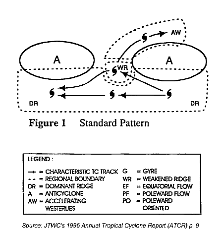
Standard Pattern (S) (Fig. 1)
Most frequently occuring pattern in the Western North Pacific (WNP); and,
Key feature is roughly zonally-oriented subtropical ridge (STR) anticyclones.
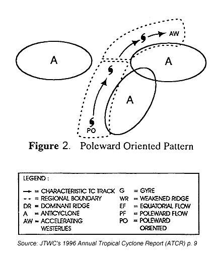
Poleward-Oriented Pattern (P) (Fig. 2)
Second highest frequency of occurrence in the WNP;
Key feature is a ridge (anticyclone) that extends from the STR deep into the tropics and interrupts the tropical easterlies;
Usually has SW-to-NE axis orientation; and,
Usually produces strong poleward steering on its west and poleward side.
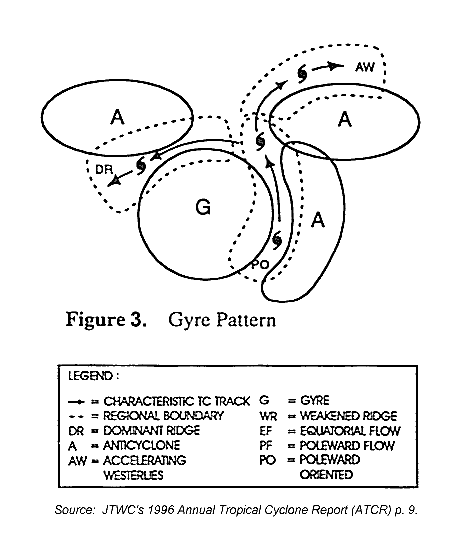
Monsoon Gyre Pattern (G) (Fig. 3)
Only occurs during June-November period;
Key feature is a particularly large and deep seasonal monsoon circulation (thus, "monsoon gyre"); and,
Usually situated between a zonally-oriented STR anticyclone to the NW and a meridionally-oriented anticyclone on its eastern periphery.
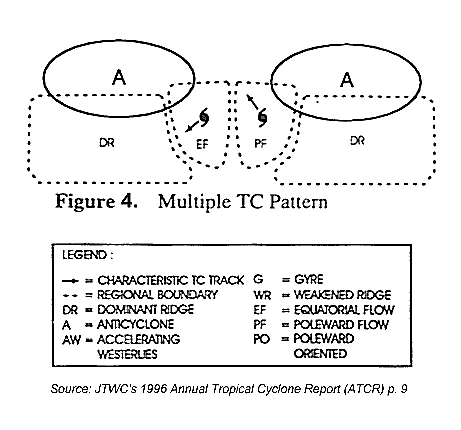
Multiple Tropical Cyclone Pattern (M) (Fig. 4)
Key feature is more than one TC with a large break in the STR in the vicinity of the two TCs;
The TCs are oriented approximately east-west (i.e., zonally-oriented TCs);
The TCs must be far enough apart to preclude significant mutual advection, but close enough to preclude the development of ridging between them (typically greater than 10°, but less than about 25°);
The average latitude of the two TCs must be sufficiently close to the latitude of the STR axis (no more than about 10° equatorward or 5° poleward) so that regions of poleward / equatorward flow are established, which affect TC motion and intensification; and,
There are three subsets of the "M" pattern which describe varying degrees of interaction between the two cyclones.
B. REGIONS - there are six primary regions associated with the four patterns:
Dominant Subtropical Ridge (DR) - the area of tropical easterlies equatorward of the STR axis, except near any break in the STR;
Weakened Subtropical Ridge (WR) - the area of weaker southeasterly winds in the vicinity of a break in the STR;
Accelerating Midlatitude Westerlies (AW) - the area of eastward and poleward steering extending east from a break in the STR;
Poleward Oriented (PO) - the area of poleward steering west of the ridge feature in the "P" and "G" Patterns;
Multiple TC Poleward Flow (PF) - created in the region of the eastern TC of a "M" Pattern as a result of the gradient between the western TC and the STR circulation to the east; and,
Multiple TC Equatorward Flow (EF) - created in the region of the western TC of a "M" Pattern as a result of the gradient between the eastern TC and the STR circulation to the west.
* - This article is taken from the Joint Typhoon Warning Center's (JTWC) 1996 Annual Tropical Cyclone Report
(ATCR), pp. 8-10.
Published: Sunday, 16 August 1998
info | previous article | home | next article